Helping Cities Protect and Serve: FLIR Provides the Technology Cities Need to Thrive

New and better-connected sensing technologies are quickly playing a bigger role in how city governments and city services are serving constituents. By combining these sensing technologies, from thermal imaging on unmanned aerial systems (UAS) to traffic monitoring, these emerging technologies can be leveraged together to improve safety and quality of life.
To maximize the value of technology investments, cities will require coordination between government organizations and key stakeholders, including individual citizens, businesses, and non-profit organizations. Together, these groups can make thoughtful, deliberate choices on not just on what technology cities will adopt, but how they will adopt that technology in the context of the broader needs of the community.
To aid in this effort, FLIR Systems has developed various technologies and products to help city governments, from those involved in public safety through to city planning, to leverage smart sensing technologies that improve efficiency and help save lives.
Public Safety Tools for Police, Fire, and Search and Rescue
FLIR-equipped personnel, unmanned aircraft, ground vehicles, and mobile surveillance systems provide swift situational awareness that speeds decisions from law enforcement to first responder teams. This also includes connected sensor solutions for detecting toxic hazards that enable city services to conduct smarter, safer investigations and rescues while making the most out of limited manpower.
For Law Enforcement:
- Built to equip law enforcement with superior thermal surveillance while packing high-performance thermal imaging into a rugged handheld monocular, the Scion PTM is capable of geotagged video recording and live video transmission, and can instantly stream encrypted thermal footage of any pursuit, evidence recovery, or search and rescue effort back to the command center via wireless network.
- Meanwhile, the Griffin 510 chemical sensors detect trace levels of chemical hazards and confirm specific chemical identities. When responding to a clandestine lab or other suspected narcotics situation, the FLIR Griffin GC-MS line of products deliver intelligence at the point of sample collection.
- For dangerous situations and conditions, the FLIR PackBot affords bomb techs, CBRNE technicians, and SWAT operators the ability to respond without putting personnel in direct harm for bomb disposal, surveillance and reconnaissance, CBRN detection, and HazMat handling operations.
- FLIR also provides for air support through airborne multi-spectral imaging systems for public safety manned aircraft—critical for tracking suspects, rescue operations, and surveillance.
For Fire and First Responders:
- Whether handheld or drone mounted, FLIR has a fleet of sensors specifically designed to safeguard people and property from harmful CBRNE substances. Rugged and extremely versatile, FLIR sensors detect chemical, biological, explosive, and radiation hazards quickly and safely. The FLIR MUVE C360 gas finder for UAS, for example, provides on-the-ground aerial support to detect potentially dangerous chemicals before sending in manned personnel.
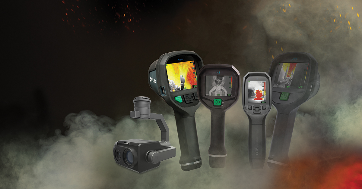
- For search and rescue operations, the TZ20 dual thermal camera for UAS provides up to twenty times digital optical zoom, enabling search and rescue teams to peer into hard-to-reach places from a crevasse to a slot canyon, or to pinpoint the hottest parts of a large structure fire to guide fire suppression efforts.
- FLIR maritime thermal imaging systems allow for spotting water traffic in total darkness, avoiding collisions, and seeing onboard activity. Thermal imaging also helps pick out navigation aids, buoys, logs, and other debris floating in the water.
Intelligent Traffic Systems for Traffic Engineers and City Planning:
Making our roads safer for pedestrians and decreasing urban congestion are important objectives for city planners. FLIR thermal imaging sensors enable cities to implement immediate changes at intersections and collect data to support long-term infrastructure planning, including detecting vehicles, bicycles, and pedestrians at and near intersections, allowing formore dynamic control of traffic lights to improve travel time and safety.
- For city planners to know which crosswalks need extra visibility, FLIR cameras can collect data about vehicle and pedestrian behavior at intersections and monitor the flow of people over time. The FLIR TrafiSense2 Dualcombines best-in-class thermal and visual imaging technology with advanced video analytics that capture accurate traffic data.
- Meanwhile, the FLIR TrafiSense AI is designed to reliably detect and classify road users, as an intelligent thermal imaging sensor for traffic monitoring in complex urban environments. Featuring AI algorithms built on 25+ years of traffic detection and best-in-class thermal imaging, TrafiSense AI delivers continuous vision and data collection for safer, more efficient cities.
FLIR cameras, sensors, and software have revolutionized how cities can improve the quality of life and safety of citizens, from improving traffic flows on roadways to locating missing persons or responding to disaster situations and criminal activity. Taken together, FLIR has a variety of technologies that can help a city of any size realize its full potential.
Related Articles
-
 Use Case Scenario
Protecting Pedestrians, Cyclists, and More with Thermal Smart Sensors
Read the Story -
 Choosing a Camera
The Complete Thermal Firefighting System
Read the Story -
 Application Story
FirstLook Robot Takes a Shotgun Blast, and Still Gets the Job Done
Read the story