Can Thermal Drone Inspections of PV Systems Save Time and Money?
It’s daunting to consider how to efficiently and accurately inspect a solar field. For asset owners, PV inspectors, and drone service providers (DSPs) to meet the growing demand they must develop a deep understanding of thermography, flight operations, and other factors to take full advantage of the benefits of drone-based solar inspection. This will also enable energy stakeholders and asset owners to further maximize efficiencies and outputs from their respective PV systems.
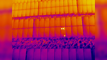
Aerial thermal imaging cameras make it easy to quickly inspect a large solar array and pinpoint solar panel problems down to cell-level defects. They streamline the completion of a qualitative analysis by allowing the operator to quickly see heat differentials across a PV system and identify possible damage or mechanical failure.
Together with Raptor Maps, FLIR has created a library of materials including a 12-page download, a four-part technical video series, and a webinar on the use of thermal drones for solar inspections. Click here to find these resources and learn more about how to minimize maintenance cycles and maximize solar output using drone-based inspections, and sign up for the live Q&A webinar for an in depth discussion and further information.
Watch the first video of the four-part series below: